Page 42 - Beaumont Basin Watermaster
P. 42

2120  2130 2140 2150  2160


 2170  ! (  Noble Creek  Little San Gorgonio Creek
 1724  Recharge Facility  Recharge Facility

 1724
 ! (
 2180  2180                2250  ! (
 2170
                                            2210
                        2240
                               2230       2200

 2180
                           2220            2190
               ! (                                ! (
                                                  2180
 2190
 2200
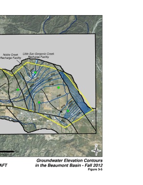
 Map Features  Noble Creek
 2210
                                  ! (                       2160
 Groundwater Elevation                                2170   2150
 Contours (ft amsl)
                                                          ! (
 Groundwater Flow Direction                                        2100

 Noble Creek                              2400
 Faults                                              2390

 Active Model Zone
 Inactive Model Zones

 ! (  Wells used in Hydrograph Analysis

 Artificial Recharge Facilities
 Beaumont Basin
 0  0.5  1  2                                                                   Ü
 Adjudicated Boundary
             Miles
 NAD 83 UTM Zone 11

 Alda, Inc.  in association with  Groundwater Elevation Contours

 DRAFT                         in the Beaumont Basin - Fall 2012
                                                                            Figure 3-5
   37   38   39   40   41   42   43   44   45   46   47