
Page 102 - Beaumont Basin Watermaster
P. 102
@
@
@
@
@
@
@
@
@
@
2013 Reevaluation of the
@
@
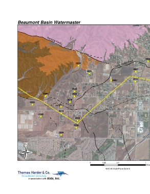
Beaumont Basin Watermaster 3-Apr-15 Beaumont Basin Safe Yield
@
@
Little San Gorgonio Creek
@
@
@ Banning Fault
@
Banning Fault
@ Map Features
@
Pumping Well for 1991
@
@ ! (
2954 Pumping Test
! ( Wildwood Canyon Fault
# * Pumping Test
@ Monitoring Well for 1991
@
! (
@ 2906 Groundwater Elevation at the
@
2626 Cherry Valley Fault ! ( time of Well Construction (ft amsl)
! (
@
@
2887 Fault
2635 ! (
@
@ Approximately Located Fault
! ( TW-2
@ @
@ @ @ # * 2265 Concealed Fault
@
2310 @ @
! (2400 @ @
! ( @ @ Concealed Fault (Bloyd, 1971) - Hypothetical
@ ! ( @ @
@
2711 @ @ @ @ where Queried
@ @ (Beaumont Basin Adjudication Boundary)
@
@ 2608 2262 @ @ @ @
! ( ! ( @ @ Pleistocene San Timoteo Deposits
2385 2606 @ @
@ @ @
@
! ( ! ( @ @ Tertiary San Timoteo and other
2529 BCVWD @ @ Tertiary Sedimentary Deposits
@ ! (
@
2250 ! ( Well 16 @ @
! ( Crystalline Basement Complex
@ @
@
@ 2273
! ( TW-1 @ @
2260 Artifical Recharge Facility
@ @
2318 # *
@
@
2348 ! ( Stream @
@
@
@
! (
2222 @
@
! (
@
@
2238 Noble Creek @
@
@
@ Note: Geology modified from California Geological
! (
Survey, Special Report 217 (Revised, 2012); @
@
@
@
2289 USGS Open-File Report 2005-1305; and
! ( USGS Scientific Investigations Report 2006-5026 @
@
@
@
(Rewis et al., 2006).
Ü
@
@
@ Groundwater levels from Department of Water Resources @
@
@ Well Completion Reports (i.e. Driller's logs) @
@
@
@ @
@
@
@
@
@
0 0.25 0.5 1
Miles
@
@
@
@
@ @ NAD 83 State Plane Zone 6 Basin Boundary Analysis
@
@
San Gorgonio Creek Area
@ @
@
@ @
@
Figure 15
@
@ @
@
@
@
@ @
@ @
@ @
@ @
@ @
@ @
@ @
@ @
@ @
@ @
@ @
@ @
@ @
@ @
@ @ @ @ @ @ @ @
@ @
@ @
@ @
@ @
@ @
@ @
@ @ @ @
@ @
@ @
@ @ @ @
@ @
@ @ @ @
@ @ @ @
@ @
@ @
@ @
@ @ @ @
@ @ @ @
@ @
@ @
@ @
@ @ @ @
@ @
@ @
@ @
@ @
@ @
@ @
@ @
@ @
@ @
@ @
@ @ @ @
@ @
@ @
@ @
@ @
@ @
@ @
@ @
@ @ @ @