
Page 19 - Beaumont Basin Watermaster
P. 19
Beaumont Basin Watermaster
2013 Reevaluation of the Beaumont Basin Safe Yield 3-Apr-15
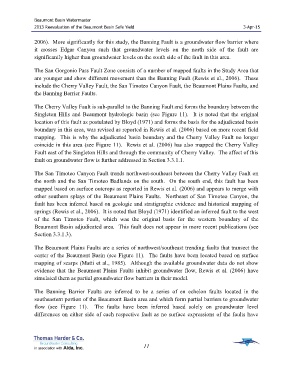
2006). More significantly for this study, the Banning Fault is a groundwater flow barrier where
it crosses Edgar Canyon such that groundwater levels on the north side of the fault are
significantly higher than groundwater levels on the south side of the fault in this area.
The San Gorgonio Pass Fault Zone consists of a number of mapped faults in the Study Area that
are younger and show different movement than the Banning Fault (Rewis et al., 2006). These
include the Cherry Valley Fault, the San Timoteo Canyon Fault, the Beaumont Plains Faults, and
the Banning Barrier Faults.
The Cherry Valley Fault is sub-parallel to the Banning Fault and forms the boundary between the
Singleton Hills and Beaumont hydrologic basin (see Figure 11). It is noted that the original
location of this fault as postulated by Bloyd (1971) and forms the basis for the adjudicated basin
boundary in this area, was revised as reported in Rewis et al. (2006) based on more recent field
mapping. This is why the adjudicated basin boundary and the Cherry Valley Fault no longer
coincide in this area (see Figure 11). Rewis et al. (2006) has also mapped the Cherry Valley
Fault east of the Singleton Hills and through the community of Cherry Valley. The affect of this
fault on groundwater flow is further addressed in Section 3.3.1.1.
The San Timoteo Canyon Fault trends northwest-southeast between the Cherry Valley Fault on
the north and the San Timoteo Badlands on the south. On the south end, this fault has been
mapped based on surface outcrops as reported in Rewis et al. (2006) and appears to merge with
other southern splays of the Beaumont Plains Faults. Northeast of San Timoteo Canyon, the
fault has been inferred based on geologic and stratigraphic evidence and historical mapping of
springs (Rewis et al., 2006). It is noted that Bloyd (1971) identified an inferred fault to the west
of the San Timoteo Fault, which was the original basis for the western boundary of the
Beaumont Basin adjudicated area. This fault does not appear in more recent publications (see
Section 3.3.1.3).
The Beaumont Plains Faults are a series of northwest/southeast trending faults that transect the
center of the Beaumont Basin (see Figure 11). The faults have been located based on surface
mapping of scarps (Matti et al., 1985). Although the available groundwater data do not show
evidence that the Beaumont Plains Faults inhibit groundwater flow, Rewis et al. (2006) have
simulated them as partial groundwater flow barriers in their model.
The Banning Barrier Faults are inferred to be a series of en echelon faults located in the
southeastern portion of the Beaumont Basin area and which form partial barriers to groundwater
flow (see Figure 11). The faults have been inferred based solely on groundwater level
differences on either side of each respective fault as no surface expressions of the faults have
11