
Page 70 - Yucaipa Sustainable Groundwater Management Agency - Yucaipa SGMA
P. 70
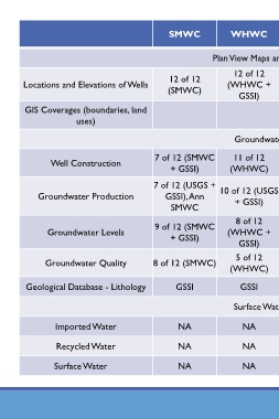
SMWC            WHWC             YVWD           Redlands           USGS             Basin

                                                        Plan View Maps and Cross-Sections

                                                             12 of 12
                                             12 of 12                         57 of 57
       Locations and Elevations of Wells                    (WHWC +                         2 of 2 (GSSI) 18 of 18 (USGS)
                                            (SMWC)                        (YVWD + GSSI)
                                                               GSSI)
       GIS Coverages (boundaries, land
                     uses)                                                                                      USGS             GSSI

                                                              Groundwater Database
                                         7 of 12 (SMWC       11 of 12         33 of 57
              Well Construction                                                             2 of 2 (GSSI) 18 of 18 (USGS)
                                             + GSSI)        (WHWC)        (YVWD + GSSI)

                                         7 of 12 (USGS +
                                                                              38 of 57
           Groundwater Production           GSSI), Ann    10 of 12 (USGS  (YVWD + GSSI)     2 of 2 (GSSI)        NA
                                                              + GSSI)
                                             SMWC
                                                              8 of 12
                                         9 of 12 (SMWC                        56 of 57      2 of 2 (Red +
             Groundwater Levels                             (WHWC +                                        18 of 18 (USGS)
                                             + GSSI)                      (YVWD + GSSI)         GSSI)
                                                               GSSI)
                                                              5 of 12         16 of 57          2 of 2
             Groundwater Quality         8 of 12 (SMWC)                                                    18 of 18 (USGS)
                                                            (WHWC)            (YVWD)         (Redlands)
        Geological Database - Lithology       GSSI             GSSI             GSSI                            USGS          USGS, GSSI

                                                             Surface Water Database


               Imported Water                  NA               NA            YVWD               NA              NA

                Recycled Water                 NA               NA            YVWD               NA              NA

               Surface Water                   NA               NA            YVWD               NA              NA