
Page 56 - Beaumont Basin Watermaster
P. 56
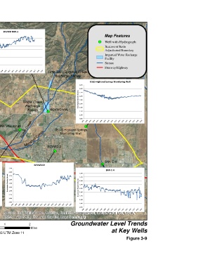
YVWD 34  BCVWD MW-1
 2,260  2,260
                                                               Map Features
 2,240
 2,240                                                      ! (  Well with Hydrograph
 Groundwater Elevation (ft amsl)  2,200  Groundwater Elevation (ft amsl)  2,200  Beaumont Basin
 2,220
 2,220
 2,180
                                                               Adjudicated Boundary
 2,180
 2,160
 2,160
 2,140
                                                               Facility
 2,120  2,140                                                  Imported Water Recharge
 2,120
                                                               Stream
 2,100
 2,100
 2,080                                                         Freeway/Highway
 2,080
 ! (                         Little San Gorgonio Creek
 YVWD 34                         Recharge Facility
 Singleton Ranch 7                                     USGS Highland Springs Monitoring Well
 2,260
                                                2,260
 Singleton Ranch 7
 2,240  ! (                                     2,240
 Groundwater Elevation (ft amsl)  2,200  Noble Creek  Groundwater Elevation (ft amsl)  2,200
 2,220
                                                2,220
 2,180
                                                2,180
 § ¨ ¦
 2,160
                                                2,160
 10
                Recharge
 2,140
                 Facility      BCVWD MW-1       2,140
 2,120                       ! (                2,120
 2,100                                          2,100
 ! (
 2,080
                                                2,080
 Tukwet Canyon
 Golf Club C  OAK VALLEY #1                        ! ( ! ( ! ( ! (
            ! ( Noble Creek       USGS Highland Springs
 San
                                     Monitoring Well
 Timoteo Wash
 U V            Ma rshall Creek  BCVWD 2
 60
                                 ! (
 Tukwet Canyon Golf Club C
 2,260
 2,240  OAK VALLEY #1  BCVWD 02                              ! (  BAN C-4
 Groundwater Elevation (ft amsl)  2,200  2,260  2,260  2,260    BAN C-4
 2,220
 2,240
      2,240
 2,180
 2,220
      2,220
 2,160
                                                2,240
 2,140
 2,180
      2,180
 2,120  Groundwater Elevation (ft amsl)  2,200  Groundwater Elevation (ft amsl)  2,200  2,220
                                                2,200
 2,100  2,160  2,160                            Groundwater Elevation (ft amsl)  2,180
 2,080  2,140  2,140                            2,160
 2,120
      2,120                                     2,140
 2,100  2,100                                   2,120
 Ü   Source: Esri, DigitalGlobe, GeoEye, Earthstar Geographics, CNES/Airbus DS, USDA,
 2,080
      2,080
                                                2,100
                                                2,080
                                           Groundwater Level Trends
 0  0.5  USGS, AeroGRID, IGN, and the GIS User Community
                  2
   1
 Alda, Inc. in association with
                   Miles
 NAD 83 UTM Zone 11                                                at Key Wells
                                                                            Figure 3-9