
Page 13 - Beaumont Basin Watermaster
P. 13
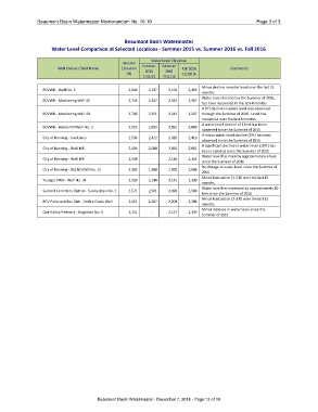
Beaumont Basin Watermaster Memorandum No. 16-19                                                 Page 3 of 3

                                       Beaumont Basin Watermaster
Water Level Comparison at Selected Locations - Summer 2015 vs. Summer 2016 vs. Fall 2016

                                              Ground    Water Level Elevation
                                             Elevation
Well Owner / Well Name                                  Summer   Summer   Fall 2016   Comments
                                                (ft)      2015     2016   11/29/16

                                                        7/31/15  7/31/16

BCVWD - Well No. 2                           2,646      2,197    2,194         2,195  Minor decline in water level over the last 15
BCVWD - Monitoring Well 4S                   2,745      2,367    2,343         2,367  months
                                                                                      Water level declined in the Summer of 2016,
BCVWD - Monitoring Well 4D                   2,746      2,251    2,242         2,247  but have recovered in the last 4 months
                                                                                      A 9 ft decline in water level was observed
BCVWD - Bonita VM Well No. 2                 2,952      2,893    2,891         2,889  through the Summer of 2016. Level has
City of Banning - Sun Lakes                  2,539      2,422    2,420         2,419  recovered over the last 4 months
City of Banning - Well M8                    2,426      2,080    2,064         2,061  A water level decline of 4 feet has been
City of Banning - Well M9                    2,558               2,136         2,142  observed since the Summer of 2015
City of Banning - Old BCVWD No. 15           2,382        -      1,990         1,988  A minor water level decline (3 ft) has been
Yucaipa VWD - Well No. 34                    2,359      1,988    2,141         2,139  observed since the Summer of 2015
Summit Cemetery District - Sunnyslope No. 1  2,571      2,140    2,499         2,509  A significant decline in water level (19 ft) has
BCV Parks and Rec Dist. - Noble Creek Well   2,621      2,501    2,209         2,206  been recorded since the Summer of 2015
Oak Valley Partners - Singleton No. 5        2,251      2,207    2,127         2,129  Water level has risen by approximately 6 feet
                                                                                      since the Summer of 2016
                                                          -                           No change in water level since the Summer of
                                                                                      2015
                                                                                      Minor fluctuation (1-2 ft) over the last 15
                                                                                      months.
                                                                                      Water level has increased by approximately 10
                                                                                      feet since the Summer of 2016
                                                                                      Minor fluctuation (2-3 ft) over the last 15
                                                                                      months.
                                                                                      Minor increase in water level since the
                                                                                      Summer of 2015

Beaumont Basin Watermaster - December 7, 2016 - Page 13 of 16