
Page 111 - Beaumont Basin Watermaster
P. 111
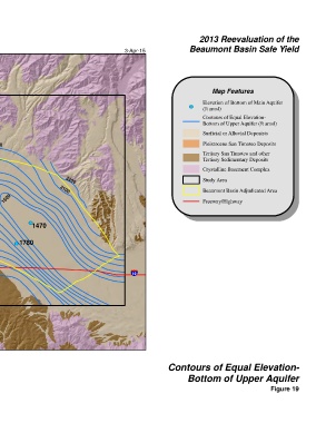
2013 Reevaluation of the
 Beaumont Basin Watermaster                     3-Apr-15                Beaumont Basin Safe Yield


 § ¨ ¦
 10


                                                                                 Map Features
 2200                                                                        Elevation of Bottom of Main Aquifer
 2100                                                                   ! (  (ft amsl)

                                                                             Contours of Equal Elevation-
                                                                             Bottom of Upper Aquifer (ft amsl)

                                                                             Surficial or Alluvial Deposists
 2000
 1800
 1700
 1700  1900  2000                                                            Pleistocene San Timoteo Deposits
 1800
                                                                             Tertiary San Timoteo and other
 1700  1900
 1700                                                                        Tertiary Sedimentary Deposits
 1800  1700  1800
 1350
 1800                                                                        Crystalline Basement Complex
 ! (  1700                2200                                               Study Area
 1900  1400  1600
 1520
 ! (  1510  ! (        2100                                                  Beaumont Basin Adjudicated Area
 1500  1600  1500                                                            Freeway/Highway
 1700
 2000  1800

            ! (
             1470
 1900
 U V
 60
 2000  ! ( 1780
 2100
 2200

 2300                                             § ¨ ¦
                                                   10


 Ü


 0  0.5  1  2
 Miles
 NAD 83 State Plane Zone 6                                      Contours of Equal Elevation-

                                                                       Bottom of Upper Aquifer
                                                                                                       Figure 19