
Page 380 - Beaumont Basin Watermaster
P. 380
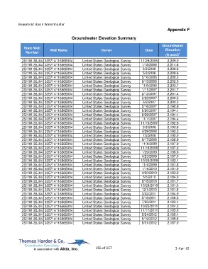
Beaumont Basin Watermaster
                                                                                                  Appendix F

                                         Groundwater Elevation Summary

                                                                                               Groundwater
             State Well                                                                         Elevation
              Number         Well Name                     Owner                     Date
                                                                                                 (ft amsl) 1
            2S/1W-35J04 335714116565004         United States Geological Survey   11/29/2005      2,209.0
            2S/1W-35J04 335714116565004         United States Geological Survey    1/18/2006      2,214.6
            2S/1W-35J04 335714116565004         United States Geological Survey    3/3/2006       2,208.6
            2S/1W-35J04 335714116565004         United States Geological Survey    5/3/2006       2,209.6
            2S/1W-35J04 335714116565004         United States Geological Survey    5/16/2006      2,208.3
            2S/1W-35J04 335714116565004         United States Geological Survey    9/15/2006      2,202.0
            2S/1W-35J04 335714116565004         United States Geological Survey    11/6/2006      2,203.7
            2S/1W-35J04 335714116565004         United States Geological Survey    1/11/2007      2,201.7
            2S/1W-35J04 335714116565004         United States Geological Survey    2/12/2007      2,201.4
            2S/1W-35J04 335714116565004         United States Geological Survey    2/22/2007      2,200.5
            2S/1W-35J04 335714116565004         United States Geological Survey    5/2/2007       2,200.3
            2S/1W-35J04 335714116565004         United States Geological Survey    5/16/2007      2,198.9
            2S/1W-35J04 335714116565004         United States Geological Survey    6/26/2007      2,194.1
            2S/1W-35J04 335714116565004         United States Geological Survey    8/29/2007      2,194.1
            2S/1W-35J04 335714116565004         United States Geological Survey    11/7/2007      2,194.4
            2S/1W-35J04 335714116565004         United States Geological Survey   11/15/2007      2,192.6
            2S/1W-35J04 335714116565004         United States Geological Survey    3/3/2008       2,193.8
            2S/1W-35J04 335714116565004         United States Geological Survey    4/29/2008      2,193.3
            2S/1W-35J04 335714116565004         United States Geological Survey    7/2/2008       2,190.0
            2S/1W-35J04 335714116565004         United States Geological Survey    9/17/2008      2,188.9
            2S/1W-35J04 335714116565004         United States Geological Survey    11/4/2008      2,187.9
            2S/1W-35J04 335714116565004         United States Geological Survey   11/18/2008      2,187.2
            2S/1W-35J04 335714116565004         United States Geological Survey    1/29/2009      2,186.6
            2S/1W-35J04 335714116565004         United States Geological Survey    4/23/2009      2,187.0
            2S/1W-35J04 335714116565004         United States Geological Survey   10/20/2009      2,182.1
            2S/1W-35J04 335714116565004         United States Geological Survey    11/4/2009      2,181.8
            2S/1W-35J04 335714116565004         United States Geological Survey    1/14/2010      2,181.9
            2S/1W-35J04 335714116565004         United States Geological Survey    4/20/2010      2,183.8
            2S/1W-35J04 335714116565004         United States Geological Survey    5/5/2010       2,184.0
            2S/1W-35J04 335714116565004         United States Geological Survey    8/18/2010      2,181.7
            2S/1W-35J04 335714116565004         United States Geological Survey   10/29/2010      2,181.5
            2S/1W-35J04 335714116565004         United States Geological Survey    12/1/2010      2,181.8
            2S/1W-35J04 335714116565004         United States Geological Survey    3/22/2011      2,184.9
            2S/1W-35J04 335714116565004         United States Geological Survey    5/18/2011      2,186.5
            2S/1W-35J04 335714116565004         United States Geological Survey    7/25/2011      2,183.1
            2S/1W-35J04 335714116565004         United States Geological Survey   10/25/2011      2,184.3
            2S/1W-35J04 335714116565004         United States Geological Survey   11/17/2011      2,185.0
            2S/1W-35J04 335714116565004         United States Geological Survey    5/24/2012      2,188.4
            2S/1W-35J04 335714116565004         United States Geological Survey    6/19/2012      2,188.6
            2S/1W-35J04 335714116565004         United States Geological Survey    8/31/2012      2,187.0


                                                       156 of 157                                      3-Apr-15