
Page 375 - Beaumont Basin Watermaster
P. 375
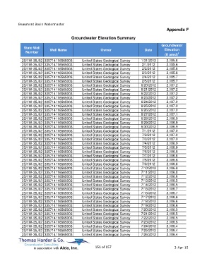
Beaumont Basin Watermaster
                                                                                                  Appendix F

                                         Groundwater Elevation Summary

                                                                                               Groundwater
             State Well                                                                         Elevation
              Number         Well Name                     Owner                     Date
                                                                                                 (ft amsl) 1
            2S/1W-35J02 335714116565003         United States Geological Survey    1/31/2012      2,185.6
            2S/1W-35J02 335714116565003         United States Geological Survey    2/1/2012       2,185.6
            2S/1W-35J02 335714116565003         United States Geological Survey    2/2/2012       2,185.6
            2S/1W-35J02 335714116565003         United States Geological Survey    2/3/2012       2,185.6
            2S/1W-35J02 335714116565003         United States Geological Survey    2/4/2012       2,185.7
            2S/1W-35J02 335714116565003         United States Geological Survey    2/5/2012       2,185.7
            2S/1W-35J02 335714116565003         United States Geological Survey    6/20/2012      2,187.2
            2S/1W-35J02 335714116565003         United States Geological Survey    6/21/2012      2,187.2
            2S/1W-35J02 335714116565003         United States Geological Survey    6/22/2012      2,187.2
            2S/1W-35J02 335714116565003         United States Geological Survey    6/23/2012      2,187.2
            2S/1W-35J02 335714116565003         United States Geological Survey    6/24/2012      2,187.0
            2S/1W-35J02 335714116565003         United States Geological Survey    6/25/2012      2,187.0
            2S/1W-35J02 335714116565003         United States Geological Survey    6/26/2012      2,187.0
            2S/1W-35J02 335714116565003         United States Geological Survey    6/27/2012      2,187.1
            2S/1W-35J02 335714116565003         United States Geological Survey    6/28/2012      2,186.9
            2S/1W-35J02 335714116565003         United States Geological Survey    6/29/2012      2,186.9
            2S/1W-35J02 335714116565003         United States Geological Survey    6/30/2012      2,186.9
            2S/1W-35J02 335714116565003         United States Geological Survey    7/1/2012       2,187.0
            2S/1W-35J02 335714116565003         United States Geological Survey    7/2/2012       2,187.0
            2S/1W-35J02 335714116565003         United States Geological Survey    7/3/2012       2,187.0
            2S/1W-35J02 335714116565003         United States Geological Survey    7/4/2012       2,186.9
            2S/1W-35J02 335714116565003         United States Geological Survey    7/5/2012       2,186.9
            2S/1W-35J02 335714116565003         United States Geological Survey    7/6/2012       2,186.8
            2S/1W-35J02 335714116565003         United States Geological Survey    7/7/2012       2,186.8
            2S/1W-35J02 335714116565003         United States Geological Survey    7/8/2012       2,186.8
            2S/1W-35J02 335714116565003         United States Geological Survey    7/9/2012       2,186.8
            2S/1W-35J02 335714116565003         United States Geological Survey    7/10/2012      2,186.8
            2S/1W-35J02 335714116565003         United States Geological Survey    7/11/2012      2,186.8
            2S/1W-35J02 335714116565003         United States Geological Survey    7/12/2012      2,186.6
            2S/1W-35J02 335714116565003         United States Geological Survey    7/13/2012      2,186.5
            2S/1W-35J02 335714116565003         United States Geological Survey    7/14/2012      2,186.5
            2S/1W-35J02 335714116565003         United States Geological Survey    7/15/2012      2,186.7
            2S/1W-35J02 335714116565003         United States Geological Survey    7/16/2012      2,186.7
            2S/1W-35J02 335714116565003         United States Geological Survey    7/17/2012      2,186.6
            2S/1W-35J02 335714116565003         United States Geological Survey    7/18/2012      2,186.6
            2S/1W-35J02 335714116565003         United States Geological Survey    7/19/2012      2,186.6
            2S/1W-35J02 335714116565003         United States Geological Survey    7/20/2012      2,186.5
            2S/1W-35J02 335714116565003         United States Geological Survey    7/21/2012      2,186.5
            2S/1W-35J02 335714116565003         United States Geological Survey    7/22/2012      2,186.5
            2S/1W-35J02 335714116565003         United States Geological Survey    7/23/2012      2,186.5
            2S/1W-35J02 335714116565003         United States Geological Survey    7/24/2012      2,186.4
            2S/1W-35J02 335714116565003         United States Geological Survey    7/25/2012      2,186.4
            2S/1W-35J02 335714116565003         United States Geological Survey    7/26/2012      2,186.4


                                                       151 of 157                                      3-Apr-15