
Page 335 - Beaumont Basin Watermaster
P. 335
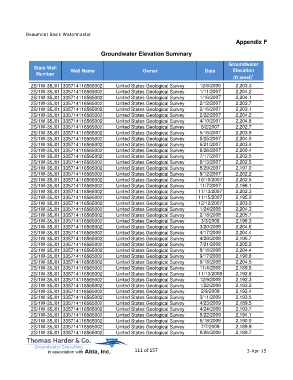
Beaumont Basin Watermaster
                                                                                                  Appendix F

                                         Groundwater Elevation Summary

                                                                                               Groundwater
             State Well                                                                         Elevation
              Number         Well Name                     Owner                     Date
                                                                                                 (ft amsl) 1
            2S/1W-35J01 335714116565002         United States Geological Survey    12/8/2006      2,203.3
            2S/1W-35J01 335714116565002         United States Geological Survey    1/11/2007      2,204.2
            2S/1W-35J01 335714116565002         United States Geological Survey    1/16/2007      2,204.1
            2S/1W-35J01 335714116565002         United States Geological Survey    2/12/2007      2,203.7
            2S/1W-35J01 335714116565002         United States Geological Survey    2/16/2007      2,203.1
            2S/1W-35J01 335714116565002         United States Geological Survey    2/22/2007      2,204.2
            2S/1W-35J01 335714116565002         United States Geological Survey    4/10/2007      2,204.8
            2S/1W-35J01 335714116565002         United States Geological Survey    5/2/2007       2,202.7
            2S/1W-35J01 335714116565002         United States Geological Survey    5/16/2007      2,203.9
            2S/1W-35J01 335714116565002         United States Geological Survey    5/25/2007      2,204.0
            2S/1W-35J01 335714116565002         United States Geological Survey    6/21/2007      2,203.4
            2S/1W-35J01 335714116565002         United States Geological Survey    6/26/2007      2,200.4
            2S/1W-35J01 335714116565002         United States Geological Survey    7/17/2007      2,202.5
            2S/1W-35J01 335714116565002         United States Geological Survey    8/13/2007      2,202.5
            2S/1W-35J01 335714116565002         United States Geological Survey    8/29/2007      2,197.0
            2S/1W-35J01 335714116565002         United States Geological Survey    9/12/2007      2,202.2
            2S/1W-35J01 335714116565002         United States Geological Survey   10/10/2007      2,202.5
            2S/1W-35J01 335714116565002         United States Geological Survey    11/7/2007      2,196.1
            2S/1W-35J01 335714116565002         United States Geological Survey   11/13/2007      2,202.3
            2S/1W-35J01 335714116565002         United States Geological Survey   11/15/2007      2,195.0
            2S/1W-35J01 335714116565002         United States Geological Survey   12/12/2007      2,203.0
            2S/1W-35J01 335714116565002         United States Geological Survey    1/24/2008      2,204.3
            2S/1W-35J01 335714116565002         United States Geological Survey    2/18/2008      2,205.7
            2S/1W-35J01 335714116565002         United States Geological Survey    3/3/2008       2,196.3
            2S/1W-35J01 335714116565002         United States Geological Survey    3/20/2008      2,204.6
            2S/1W-35J01 335714116565002         United States Geological Survey    4/17/2008      2,204.4
            2S/1W-35J01 335714116565002         United States Geological Survey    4/29/2008      2,195.7
            2S/1W-35J01 335714116565002         United States Geological Survey    7/21/2008      2,205.2
            2S/1W-35J01 335714116565002         United States Geological Survey    8/18/2008      2,204.4
            2S/1W-35J01 335714116565002         United States Geological Survey    9/17/2008      2,190.8
            2S/1W-35J01 335714116565002         United States Geological Survey    9/18/2008      2,204.5
            2S/1W-35J01 335714116565002         United States Geological Survey    11/4/2008      2,189.5
            2S/1W-35J01 335714116565002         United States Geological Survey   11/13/2008      2,192.8
            2S/1W-35J01 335714116565002         United States Geological Survey    12/9/2008      2,192.3
            2S/1W-35J01 335714116565002         United States Geological Survey    1/22/2009      2,193.2
            2S/1W-35J01 335714116565002         United States Geological Survey    2/9/2009       2,193.4
            2S/1W-35J01 335714116565002         United States Geological Survey    3/11/2009      2,193.5
            2S/1W-35J01 335714116565002         United States Geological Survey    4/23/2009      2,189.5
            2S/1W-35J01 335714116565002         United States Geological Survey    4/24/2009      2,193.7
            2S/1W-35J01 335714116565002         United States Geological Survey    5/22/2009      2,194.1
            2S/1W-35J01 335714116565002         United States Geological Survey    6/18/2009      2,190.0
            2S/1W-35J01 335714116565002         United States Geological Survey    7/7/2009       2,189.9
            2S/1W-35J01 335714116565002         United States Geological Survey    8/26/2009      2,189.7


                                                       111 of 157                                      3-Apr-15