
Page 351 - Beaumont Basin Watermaster
P. 351
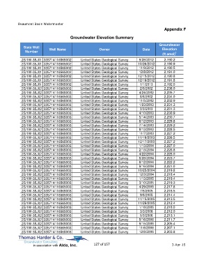
Beaumont Basin Watermaster
                                                                                                  Appendix F

                                         Groundwater Elevation Summary

                                                                                               Groundwater
             State Well                                                                         Elevation
              Number         Well Name                     Owner                     Date
                                                                                                 (ft amsl) 1
            2S/1W-35J01 335714116565002         United States Geological Survey    9/28/2012      2,190.2
            2S/1W-35J01 335714116565002         United States Geological Survey   10/26/2012      2,190.9
            2S/1W-35J01 335714116565002         United States Geological Survey    11/9/2012      2,190.5
            2S/1W-35J01 335714116565002         United States Geological Survey    12/8/2012      2,191.0
            2S/1W-35J01 335714116565002         United States Geological Survey   12/15/2012      2,190.8
            2S/1W-35J01 335714116565002         United States Geological Survey   12/19/2012      2,191.8
            2S/1W-35J01 335714116565002         United States Geological Survey    1/1/2013       2,192.0
            2S/1W-35J02 335714116565003         United States Geological Survey    2/5/2002       2,236.0
            2S/1W-35J02 335714116565003         United States Geological Survey    4/24/2002      2,235.7
            2S/1W-35J02 335714116565003         United States Geological Survey    8/8/2002       2,234.0
            2S/1W-35J02 335714116565003         United States Geological Survey    11/5/2002      2,232.9
            2S/1W-35J02 335714116565003         United States Geological Survey    1/23/2003      2,231.3
            2S/1W-35J02 335714116565003         United States Geological Survey    3/3/2003       2,231.3
            2S/1W-35J02 335714116565003         United States Geological Survey    4/10/2003      2,230.9
            2S/1W-35J02 335714116565003         United States Geological Survey    5/14/2003      2,230.7
            2S/1W-35J02 335714116565003         United States Geological Survey    6/12/2003      2,229.8
            2S/1W-35J02 335714116565003         United States Geological Survey    7/14/2003      2,229.2
            2S/1W-35J02 335714116565003         United States Geological Survey    8/13/2003      2,228.5
            2S/1W-35J02 335714116565003         United States Geological Survey    11/7/2003      2,227.2
            2S/1W-35J02 335714116565003         United States Geological Survey   11/19/2003      2,226.5
            2S/1W-35J02 335714116565003         United States Geological Survey   12/17/2003      2,227.2
            2S/1W-35J02 335714116565003         United States Geological Survey    1/13/2004      2,227.0
            2S/1W-35J02 335714116565003         United States Geological Survey    2/13/2004      2,226.8
            2S/1W-35J02 335714116565003         United States Geological Survey    4/22/2004      2,225.0
            2S/1W-35J02 335714116565003         United States Geological Survey    6/28/2004      2,223.7
            2S/1W-35J02 335714116565003         United States Geological Survey    8/12/2004      2,222.2
            2S/1W-35J02 335714116565003         United States Geological Survey    9/16/2004      2,221.0
            2S/1W-35J02 335714116565003         United States Geological Survey   10/25/2004      2,219.8
            2S/1W-35J02 335714116565003         United States Geological Survey    12/3/2004      2,218.4
            2S/1W-35J02 335714116565003         United States Geological Survey    1/13/2005      2,219.4
            2S/1W-35J02 335714116565003         United States Geological Survey    3/10/2005      2,219.3
            2S/1W-35J02 335714116565003         United States Geological Survey    4/29/2005      2,217.8
            2S/1W-35J02 335714116565003         United States Geological Survey    7/6/2005       2,216.5
            2S/1W-35J02 335714116565003         United States Geological Survey    9/8/2005       2,214.4
            2S/1W-35J02 335714116565003         United States Geological Survey   11/15/2005      2,213.5
            2S/1W-35J02 335714116565003         United States Geological Survey   11/29/2005      2,212.4
            2S/1W-35J02 335714116565003         United States Geological Survey    1/18/2006      2,218.0
            2S/1W-35J02 335714116565003         United States Geological Survey    3/3/2006       2,212.0
            2S/1W-35J02 335714116565003         United States Geological Survey    5/3/2006       2,213.1
            2S/1W-35J02 335714116565003         United States Geological Survey    5/16/2006      2,211.7
            2S/1W-35J02 335714116565003         United States Geological Survey    9/15/2006      2,205.4
            2S/1W-35J02 335714116565003         United States Geological Survey    11/6/2006      2,207.1
            2S/1W-35J02 335714116565003         United States Geological Survey    12/8/2006      2,203.8


                                                       127 of 157                                      3-Apr-15